
destination
Skydance Bridge
What people say
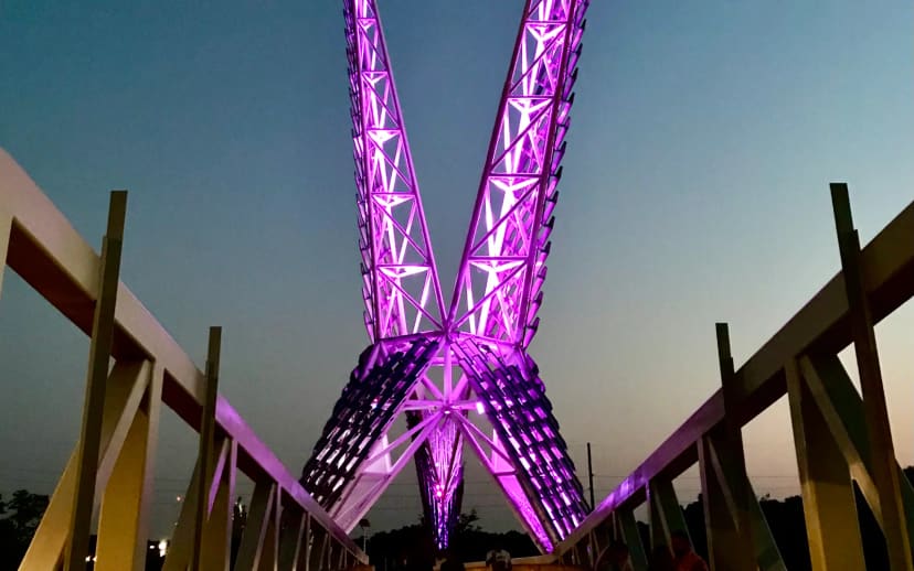
Skydance Bridge is a 380-foot pedestrian bridge and illuminated landmark inspired by Oklahoma's state bird; it links Scissortail Park's Upper and Lower parks across Interstate 40. This is a through-route shared by people walking, running, and bicycling, not a roadside overlook. Stay on the pedestrian path, supervise children, keep the route clear when taking photos, and use the exact pin to find the Interstate 40 crossing between the Upper and Lower parks.
At this place
Upcoming events
Inside this place
Explore the grounds
Choose a destination, preview what it looks like, then open Explorer for live on-site guidance.
Public record
Verified information
What people ask
Useful answers about this place
Frequently requested details, researched and kept current by AuditMap.
Where exactly is Skydance Bridge?
Skydance Bridge is a 380-foot pedestrian bridge and illuminated landmark inspired by Oklahoma's state bird; it links Scissortail Park's Upper and Lower parks across Interstate 40. Navigate to the exact Skydance Bridge pin rather than the general Scissortail Park marker. This is a through-route shared by people walking, running, and bicycling, not a roadside overlook. Stay on the pedestrian path, supervise children, keep the route clear when taking photos, and use the exact pin to find the Interstate 40 crossing between the Upper and Lower parks.
Where should I park for Skydance Bridge?
Metered two-hour street spaces line S. Hudson, Oklahoma City Boulevard, and S. Robinson. Nearby Convention Center, Sheridan Walker, Arts District, and Century Center garages are listed at $2 per hour or $10 per day; event pricing can vary. Navigate to the exact Skydance Bridge pin rather than the general Scissortail Park marker. This is a through-route shared by people walking, running, and bicycling, not a roadside overlook. Stay on the pedestrian path, supervise children, keep the route clear when taking photos, and use the exact pin to find the Interstate 40 crossing between the Upper and Lower parks.
When is Skydance Bridge open?
The bridge is an outdoor pedestrian connection within the Scissortail Park campus. Plan around the park's daily 6:00 a.m.-11:00 p.m. hours and obey any closure or event-control signs at the approaches.
Are there restrooms near Skydance Bridge?
Yes. Public restrooms are available near major destinations, including the playground and Scissortail Boathouse. The Boathouse also has a shaded patio and cafe; Lower Park facilities may follow sports or event operations.
What fees apply at Skydance Bridge?
Walking across Skydance Bridge is free; nearby parking, food, rentals, and ticketed park events can cost separately.
How accessible is Skydance Bridge?
The park provides accessible perimeter parking, restrooms, ground-level paths, ramps to the stage and boathouse, accessible playground and workout equipment, Braille entry and restroom signs, an accessible pedal boat, and Silver Flyer mobility tours.
Are dogs allowed at Skydance Bridge?
The park has a half-acre fenced dog park with separate areas for large and small dogs, drinking fountains, and boulders. Dogs must remain leashed everywhere outside the enclosure and are not permitted in the sprayground water. Separately operated buildings, beaches, gardens, and attractions can set stricter rules.
Is Skydance Bridge useful for a family visit?
Skydance Bridge is a 380-foot pedestrian bridge and illuminated landmark inspired by Oklahoma's state bird; it links Scissortail Park's Upper and Lower parks across Interstate 40. The children's playground is open from dawn to dusk. It includes climbing walls, geometric dome climbers, children's gardens, a large fort with tower and slides, shade, nearby public restrooms, and adjacent interactive fountains.
What should I know before visiting Skydance Bridge?
This is a through-route shared by people walking, running, and bicycling, not a roadside overlook. Stay on the pedestrian path, supervise children, keep the route clear when taking photos, and use the exact pin to find the Interstate 40 crossing between the Upper and Lower parks.
Quick community check
Help verify this place
Know this place? Check one detail from a recent visit.
✓ Accurate × Incorrect ? Unsure
Community for this place
What people are noticing
Ask a question, share what changed, or help make a detail more reliable.
The place logUseful questions, updates, and confirmations from this community.
Keep exploring
Nearby public places
Based on this place's location and public details, not your activity.