
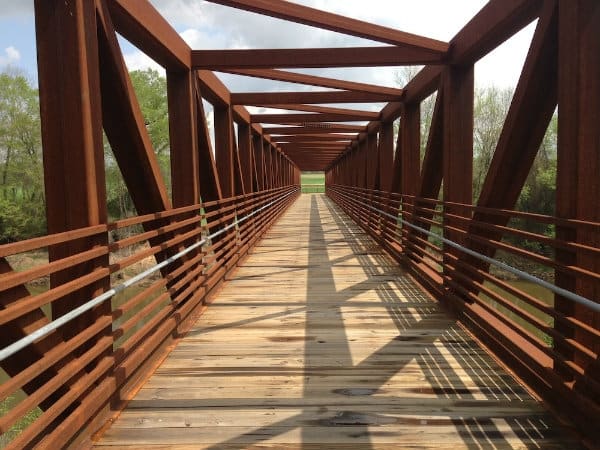
Long-distance paved river greenway
Neuse River Greenway Trail
What people say
A 27.5-mile paved Raleigh greenway following the Neuse River from Falls Lake Dam to the Wake-Johnston County line, with boardwalks, river access, park connections, and links to neighboring trail systems.
At this place
Upcoming events
Inside this place
Explore the grounds
Choose a destination, preview what it looks like, then open Explorer for live on-site guidance.
Public record
Verified information
What people ask
Useful answers about this place
Frequently requested details, researched and kept current by AuditMap.
Where should I park for the Neuse River Greenway Trail?
Choose a segment first; there is no single best lot. Documented access includes Falls Lake Dam at 12098 Old Falls of Neuse Road, Horseshoe Farm at 2900 Horseshoe Farm Road, Buffaloe Road Athletic Park at 5812 Buffaloe Road, 5428 Allen Drive, Anderson Point Park at 20 and 22 Anderson Point Drive, 1721 Riverview Road, Auburn Knightdale Road, and Mial Plantation Road. Verify the current map and alerts before driving.
What is the best trailhead for the Neuse River Greenway?
Falls Lake Dam begins the official mileage; Horseshoe Farm and Buffaloe Road serve northern sections; Milburnie offers river and historical scenery; Anderson Point connects with Crabtree Creek and Knightdale routes; Auburn Knightdale and Mial Plantation serve southern miles. Anderson Point is the directory address, not the only entrance.
Are there restrooms along the Neuse River Greenway?
Some connected parks and trailheads have restrooms, but they are not continuous and may not be open during every trail hour. Use Raleigh's Greenway Explorer to find a documented restroom near your segment, then verify the host park's hours. Carry water and do not assume the next access point has an unlocked restroom.
What hours is the Neuse River Greenway open?
The greenway is open dawn to dusk daily. City river launches are open sunrise to sunset. Connected parks, gates, restrooms, and neighboring jurisdictions can close at different times, so plan to return before the applicable closing time.
Is the Neuse River Greenway free?
Yes. Walking, running, or cycling on the public trail is free. Equipment, programs, food vendors, transportation, or activities at connected destinations may cost separately. Vehicles may not be left overnight at City river-access parking lots.
Is the Neuse River Greenway wheelchair accessible?
The 27.5-mile main route is paved and many portions can work for wheelchairs and mobility devices, but the corridor is not uniformly accessible. Trailhead transitions, slopes, bridge approaches, flooding, construction, and pavement conditions vary. Check the exact segment in the City's Explorer and alerts.
How long is the Neuse River Greenway and is it paved?
Raleigh's official route is 27.5 miles and paved, running from Falls Lake Dam to the Wake-Johnston County line. City distances assume a start at Falls Lake Dam. Neighboring continuations can make a longer outing but are outside Raleigh's stated mileage.
Is the Neuse River Greenway a loop?
No. It is a long linear trail. For a short visit, plan an out-and-back and turn around after half your desired total distance. For a one-way trip, arrange a legal shuttle or pickup and confirm both parking areas and closing times; do not assume transit, rideshare, food, water, or repairs will be available at a remote turnaround.
Where does the Neuse River Greenway connect?
It connects with Abbotts Creek Trail, Buffaloe Road Athletic Park, Anderson Point Park, Milburnie Dam, Crabtree Creek Trail, Walnut Creek Trail, and routes toward Wake Forest, Knightdale, and Johnston County. It is part of the Mountains-to-Sea Trail, but it is not a continuous Raleigh-to-Charlotte greenway.
Can I canoe, kayak, or fish from the Neuse River Greenway?
Yes, at designated access locations rather than every trail point. Raleigh provides six launches for non-motorized paddlecraft along 17 miles of the Neuse beginning at Falls Lake Dam, and the corridor offers fishing. Check launch and river conditions, use proper flotation equipment, and never assume a trail parking point is a boat launch.
Are dogs allowed on the Neuse River Greenway?
Yes. Dogs must be controlled on a leash no longer than six feet, stay to the right, and owners must remove waste. A short non-retractable leash is safest around bicycles, wildlife, children, bridges, and narrow boardwalk approaches.
Can I bike the Neuse River Greenway?
Yes. The paved route is shared with walkers, runners, mobility devices, and other users. Raleigh's greenway speed limit is 10 mph: keep right, yield to pedestrians, announce passes on the left, and slow at curves, bridges, boardwalks, trailheads, children, and dogs.
Does the Neuse River Greenway flood or close?
Yes. High water, debris, bridge work, maintenance, or construction can affect this river and wetland corridor. Check Greenway Alerts immediately before a longer trip. Never cross a barricade, enter moving water, or detour across private property or a high-speed road.
Is there food or water on the Neuse River Greenway?
The City lists a food-vendor location near 12098 Old Falls of Neuse Road, but vendor attendance is not guaranteed. Treat most of the 27.5-mile corridor as a bring-your-own-water and snacks trip, and never plan a long ride around an unconfirmed vendor.
Quick community check
Help verify this place
Know this place? Check one detail from a recent visit.
✓ Accurate × Incorrect ? Unsure
Community for this place
What people are noticing
Ask a question, share what changed, or help make a detail more reliable.
The place logUseful questions, updates, and confirmations from this community.
Keep exploring
Nearby public places
Based on this place's location and public details, not your activity.