
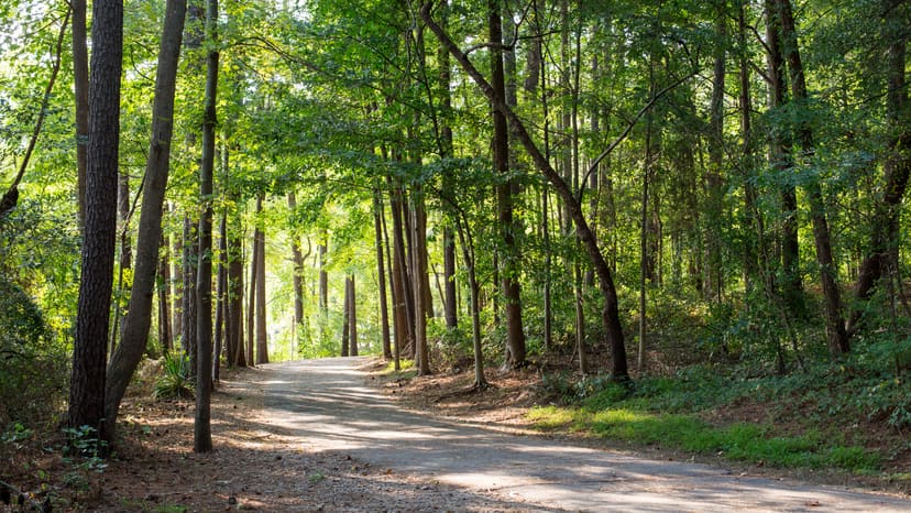
Paved lakeside greenway and natural-surface trail network
Lake Johnson Loop Trails
What people say
Lake Johnson's trail system pairs a 2.8-mile paved East Loop and Walnut Creek Greenway connection with quieter natural-surface west-side trails, waterfront facilities, lake views, fitness and poetry stops, fishing access, and multiple trailheads.
At this place
Upcoming events
Inside this place
Explore the grounds
Choose a destination, preview what it looks like, then open Explorer for live on-site guidance.
Public record
Verified information
What people ask
Useful answers about this place
Frequently requested details, researched and kept current by AuditMap.
Where should I park for the Lake Johnson loop trails?
For the East Loop and services, use the Waterfront Center at 4601 Avent Ferry Road, the south lot at 5051 Avent Ferry Road, or the dam lot at 1320 Lake Dam Road. For west-side natural trails, the clearest start is Thomas G. Crowder Woodland Center at 5611 Jaguar Park Drive; the south lot also links both sides. Use only marked park spaces.
Which Lake Johnson trail entrance is best for a first visit?
Start at the Waterfront Center, 4601 Avent Ferry Road, for the paved East Loop, accessible restrooms, covered lake overlook, accessible fishing dock, staff-area orientation, and direct trail access. Start at Crowder Woodland Center for the wooded west-side trails, QR fitness route, and Interpretive Poetry Trail.
Are there restrooms on the Lake Johnson loops?
Accessible restrooms are available at the Waterfront Center and Thomas G. Crowder Woodland Center, and the City says park bathrooms are open sunrise to sunset. Other buildings and seasonal facilities have separate hours. Choose the starting center that matches your route rather than assuming a restroom appears midway around the lake.
What hours are the Lake Johnson trails open?
The park trails and bathrooms are open sunrise to sunset. The Waterfront Center, Crowder Woodland Center, pool, boat rentals, and programs follow their own schedules. Begin early enough to complete the chosen loop and return before sunset.
Are the Lake Johnson loop trails free?
Yes. Walking, running, and general trail access are free. Boat rentals, paddling programs, pool admission, reserved facilities, and other programs may charge. Fishing from approved locations requires a current North Carolina fishing license.
Which Lake Johnson loop is most accessible?
Choose the paved East Loop and Waterfront Center. That lot has three accessible spaces, an entrance ramp, accessible restrooms, covered deck and lake overlook, and an accessible fishing dock. The natural-surface west side has roots, changing grades, and variable conditions and should not be treated as an equivalent accessible loop.
What is the difference between Lake Johnson's East and West loops?
The East Loop is the 2.8-mile paved greenway around the east side and is part of Walnut Creek Greenway. The current park page describes about 1.5 miles of unpaved natural-surface trail on the west side, while the system trail list labels a 2.1-mile West Loop. Use the park map for the exact west-side route rather than assuming every west path forms one paved loop.
Can I walk all the way around Lake Johnson?
The East Loop is a documented 2.8-mile paved loop, while west-side natural trails can be combined using the park map. Roads, the lake crossing, and trail junctions can make an all-lake route less obvious than a single circle. For a predictable first trip, complete the East Loop or choose a mapped west-side out-and-back from Crowder Woodland Center.
Can I bike the Lake Johnson loops?
Biking is allowed only on greenway trails. The paved East Loop supports bicycles under Raleigh's shared-trail rules and 10 mph speed limit. Bikes are not permitted on the south half of the west-side natural trail section. Check the park map at junctions and do not ride onto hiking-only paths.
Are dogs allowed on the Lake Johnson trails?
Yes. Dogs must be under control on a leash no longer than six feet, and owners must remove waste. Keep dogs out of the water, yield on narrow natural trails, and use extra care around bicycles, wildlife, fishing lines, and crowded boardwalk areas.
Where is the QR fitness trail at Lake Johnson?
Six QR fitness stations cover roughly a one-mile loop on the west side, accessible from Thomas G. Crowder Woodland Center at 5611 Jaguar Park Drive. A phone with cellular data is needed to open the exercise videos. The stations cover upper body, core, flexibility, and lower-body exercises.
Where is the Lake Johnson Interpretive Poetry Trail?
The one-mile Interpretive Poetry Trail is on the wooded west side and features work by ten local poets on signs along natural-surface trails. Start from the Crowder Woodland Center side and use the City's interactive poetry map; it is a quieter nature-and-art walk, not the paved East Loop.
Can I swim or wade from the Lake Johnson trails?
No. Swimming and wading are prohibited. Fishing is allowed only from the boardwalk, fishing pier, designated bank area, or personal paddlecraft under applicable regulations. Use designated water access and never enter the lake from a trail edge.
Do the Lake Johnson trails close after storms?
Trail conditions can change because of storms, fallen trees, flooding, erosion, prescribed burns, maintenance, or events. Check Lake Johnson park alerts and Raleigh greenway alerts before visiting. Natural-surface west trails are especially sensitive to wet conditions; avoid muddy paths rather than widening them.
Quick community check
Help verify this place
Know this place? Check one detail from a recent visit.
✓ Accurate × Incorrect ? Unsure
Community for this place
What people are noticing
Ask a question, share what changed, or help make a detail more reliable.
The place logUseful questions, updates, and confirmations from this community.
Keep exploring
Nearby public places
Based on this place's location and public details, not your activity.