
Park
Smith Creek Greenway
What people say
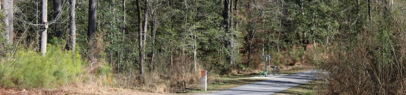
Smith Creek Greenway's southern segment is a 1.15-mile, 10-foot-wide paved asphalt trail through partly shaded creek and wetland habitat, crossing the Neuse on a 558-foot pedestrian bridge and connecting to the much longer Neuse River Greenway network.
At this place
Upcoming events
Inside this place
Explore the grounds
Choose a destination, preview what it looks like, then open Explorer for live on-site guidance.
Public record
Verified information
What people ask
Useful answers about this place
Frequently requested details, researched and kept current by AuditMap.
What address or entrance should I use for Smith Creek Greenway?
The southern 1.15-mile segment extends from Burlington Mills Road to the Neuse River Greenway. Official parking is reached through the Neuse network at WRAL Soccer Park, 7700 Perry Creek Road; Horseshoe Nature Preserve, 2900 Horse Shoe Farm Road; or Thornton Road access, 6100 Thornton Road.
Where should I park for Smith Creek Greenway?
The Town directs visitors to WRAL Soccer Park, Horseshoe Nature Preserve, or Thornton Road Greenway access, then to Smith Creek via the Neuse River Greenway. Do not assume Burlington Mills Road provides a full public trailhead lot.
When is Smith Creek Greenway open?
The greenway is open dawn to dusk. Start early enough to complete the out-and-back or connected route before dark, since the trail and bridge are not intended as an after-hours corridor.
Is Smith Creek Greenway free?
Greenway access is free. Parking, programs, or facilities at connected parks may have their own rules, and riders are responsible for repair, transit, or pickup costs on long one-way trips.
Are there restrooms at Smith Creek Greenway?
The Town does not list restrooms on the 1.15-mile southern segment. Restroom availability at connected parks or trailheads varies, so use facilities before entering and do not rely on an open building along the route.
What accessibility information should I know about Smith Creek Greenway?
The principal trail is 10-foot-wide paved asphalt and the river crossing is a large pedestrian bridge. Grades, bridge approaches, wet leaves, debris, flooding, and distances to parking can affect access; plan an achievable turnaround.
What are the paths or trails like at Smith Creek Greenway?
The trail runs 1.15 miles one way from Burlington Mills Road south along Smith Creek to the Neuse River Greenway. It is paved asphalt, 10 feet wide, partly shaded, and can become part of a roughly 33-mile one-way connected route.
What can families do at Smith Creek Greenway?
Creek and wetland views, shade, wildlife, and the 558-foot bridge can make a memorable family ride or walk. There is no playground on this segment, and the distance from official parking makes turnaround planning important.
Can I bring a dog to Smith Creek Greenway?
Keep dogs leashed, under close control, and on the paved trail; remove all waste. Carry water and avoid blocking cyclists or other users on the bridge and narrower approach areas.
Can I picnic at Smith Creek Greenway?
There are no documented picnic facilities on the southern segment itself. Use designated picnic areas at connected parks and keep trail shoulders, bridge approaches, wetlands, and private neighborhood access clear.
What landmarks or areas should I look for at Smith Creek Greenway?
The defining features are Smith Creek, aquatic and wetland habitat, partial forest shade, the 558-foot pedestrian bridge over the Neuse River, neighborhood connections near Creek Moss Avenue, and the junction with the Neuse River Greenway.
What closures or conditions can affect Smith Creek Greenway?
Flooding, storms, sewer or greenway construction, bridge maintenance, and debris can close or narrow the route. Planned northern extensions do not yet make this southern segment continuous with every other Smith Creek section; verify current detours before a long trip.
Quick community check
Help verify this place
Know this place? Check one detail from a recent visit.
✓ Accurate × Incorrect ? Unsure
Community for this place
What people are noticing
Ask a question, share what changed, or help make a detail more reliable.
The place logUseful questions, updates, and confirmations from this community.
Keep exploring
Nearby public places
Based on this place's location and public details, not your activity.