

 1
destination
1
destination
Park
Phoenix Mountains Preserve
What people say
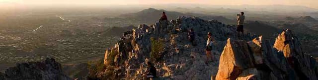
A large central desert preserve surrounding 2,608-foot Piestewa Peak and Dreamy Draw, with extremely difficult summit hiking, quieter valleys, multiple trailheads, multi-use routes, restrooms, water, and city views.
At this place
Upcoming events
Inside this place
Explore the grounds
Choose a destination, preview what it looks like, then open Explorer for live on-site guidance.
1
destination
 2
destination
2
destination
Piestewa Peak Freedom Trail
Freedom Trail circles the peak for 3.7 rocky miles with about 720 feet of gain and shares a busy section with the Summit route. 3
destination
3
destination
Piestewa Peak Nature Trail
The 1.4-mile Nature Trail starts at 304 and offers a moderate Sonoran Desert loop with less elevation than the Summit. 4
destination
4
destination
Dreamy Draw Recreation Area
Dreamy Draw provides trailheads, picnic ramadas, restrooms, water, and connections to a large multi-use network north of Piestewa Peak.
5
destination
302 Trailhead
The 302 trailhead is the principal Summit and Freedom access with water and restrooms; its lot fills early and summer entry hours differ.
6
destination
304 Trailhead
The 304 trailhead reaches the Nature Trail and lower routes with water and restrooms without committing to the Summit climb.
7
destination
40th Street Trailhead
The 40th Street trailhead offers water, restrooms, shade, and L.V. Yates access into quieter eastern preserve routes.
8
destination
Charles M. Christiansen Memorial Trail
Trail 100 is a long cross-city multi-use route intersecting several preserve trailheads; users must plan crossings, distance, and pickup.Public record
Verified information
What people ask
Useful answers about this place
11 answers
Frequently requested details, researched and kept current by AuditMap.
When is Phoenix Mountains Preserve open?
Parking entrances are generally open 5:00 a.m.-7:00 p.m.; Piestewa Peak parking remains open until 9:00 p.m. June 1-September 30. Trails are open 5:00 a.m.-11:00 p.m.
Where should I park for Phoenix Mountains Preserve?
The 302, 304, Dreamy Draw, 32nd Street, 40th Street, and Myrtle trailheads reach different routes. Summit parking fills early and an open trail does not mean the lot entrance remains open.
What is the best entrance for Phoenix Mountains Preserve?
Use the 302 trailhead for the Summit and Freedom trails, 304 for the Nature Trail, or Dreamy Draw and neighborhood trailheads for less concentrated routes.
Are there restrooms at Phoenix Mountains Preserve?
Restrooms and drinking fountains are available at several major trailheads, including the Summit base, but not on the mountain or every neighborhood access.
Is Phoenix Mountains Preserve free?
Preserve access, trails, and parking are free. Guided programs, equipment, transportation, and external services may charge.
How accessible is Phoenix Mountains Preserve?
Developed trailhead facilities offer accessible elements, but the Summit Trail is extremely difficult, steep, jagged, and stair-like. Easier paved or low-gradient alternatives are limited.
Are dogs allowed at Phoenix Mountains Preserve?
Dogs are prohibited year-round on the Piestewa Peak Summit Trail and must follow posted leash rules elsewhere. Heat makes even allowed routes dangerous for pets.
Is Phoenix Mountains Preserve good for children?
Dreamy Draw, the Nature Trail, and short lower routes are more appropriate than the Summit for many families. Match the route to the least experienced person.
How do I reach Phoenix Mountains Preserve without a car?
Driving or rideshare is common, but full lots and pickup constraints require a backup. Some trailheads are reachable by bike or neighborhood walking only in safe temperatures.
What should I know before visiting Phoenix Mountains Preserve?
The 1.2-mile Summit Trail gains about 1,200 feet and is rated extremely difficult. On Extreme Heat Warning days, Piestewa trails are restricted 8:00 a.m.-5:00 p.m.; start before sunrise only where gates permit and carry more water than expected.
What weather should I check before visiting Phoenix Mountains Preserve?
Check Phoenix's hourly temperature and heat index, National Weather Service Extreme Heat Warnings, trail restrictions, air quality, lightning, monsoon storms, flash-flood risk, and current park notices. Exposed rock, metal, pavement, play equipment, and pet paws can reach dangerous temperatures long before afternoon.
Quick community check
Help verify this place
Know this place? Check one detail from a recent visit.
✓ Accurate × Incorrect ? Unsure
Community for this place
What people are noticing
Ask a question, share what changed, or help make a detail more reliable.
The place logUseful questions, updates, and confirmations from this community.
Keep exploring
Nearby public places
Based on this place's location and public details, not your activity.